So I've been playing around with Google Earth since yesterday and let me tell you, the thing is just amazing! What is Google Earth, you might ask? Well, for those of you not in touch with your Geekuality, Google Earth is a piece of software which:
"combines satellite imagery, maps and the power of Google Search to put the world's geographic information at your fingertips."
According to the project page found at http://earth.google.com, you can do all sort of cool stuff like:
According to the project page found at http://earth.google.com, you can do all sort of cool stuff like:
- Fly from space to your neighborhood. Type in an address and zoom right in.
- Search for schools, parks, restaurants, and hotels.
- Get driving directions.
- Tilt and rotate the view to see 3D terrain and buildings.
So, in other words, Google Earth represents the Geographer's Dream, The Bored Man's Salvation, and the Voyeur's Fantasy Come True. Naturally, I fall in to the category of the bored man looking for something new to optimize his time on the web! (I know what Mad Bull and Dr. D. would do with this thing, since I know that they are neither interested in Geography nor have time to be bored with their hectic lifestyles!).
Anyhow, I thought it would be cool to Google Earth a few places of interest and see what turned up. Here are the results:
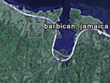 The first logical spot I thought to look for was my home in Jamaica. Unfortunately, I couldn't get a good feel for where in Barbican I was, so I gave up on this image.
 Next I decided to try somewhere in the US and, of course, the most logical place to check out would be my current location...the office. I couldn't really identify too many things in this image either, I guess the foliage is just too dense for this satellite imagery stuff.
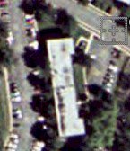 Eventually, I decided to try somewhere bigger and less rural. ..Pebble's apartment complex. Lo and behold, I see buildings, cars, trees, and all manner of coolness. I can actually make out her building from here! Wow, this is totally incredible!
 Now it's my turn. I point Google Earth at my address and I can see with extreme clarity the terrain of the apartment complex! I see the swimming pool, my friend's apartment, the laudromat, and my own apartment! Wow, this is amazing. I can actually trace my way from my apartment building to the downtown area and the campus of my alma mater! The thing that has me completely freaked out about this technology is that it's extremely fast, accurate, and free!
They offer several pay versions of the software available which boast even more clarity, greater accuracy, and better search features! If this is available to the public, then just imagine the power of the technology the feds have at their disposal! I'll never get naked in my apartment again! Anyhow good friends, I'm out, it's late and I plan to go home and get some well-deserved rest! Be sure to download Google Earth now and try it out for yourself, if you haven't done so already!
{Nuff Said}
Comments